United States
|
||||||||||||||||||||||||||||||||
The United States of America is the largest country in North America and the third largest in the world in terms of population.
Useful Knowledge
Google Car
The United States is covered by all 4 generations and is the most covered country in the world. Both the expanse of land and coverage makes it difficult to identify where you are based on the Google Car.
License Plates
Identifying where you are based on the license plates is a widely used tactic by players. For the United States however, it can be very difficult. All 50 states, and most territories, have their own license plates. That means it can be tedious to learn the license plates of each state, but if you do, it will help you identify where you are faster and more accurately.
Street Signs
https://wiki.openstreetmap.org/wiki/United_States/Road_signs
Bollards
Roads
Interstate System

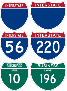
The United States Interstate system is one of the largest systems of roadways in the world. At least one interstate runs through each of the 48 contiguous states. As shown in the Street Signs section, the United States Interstate system primarly uses a sign with white lettering, a blue background, and a red heading at the top which reads "INTERSTATE". Occasionally, an Interstate will have white lettering with a completely green background, and it will typically have "BUSINESS" as the header instead of "INTERSTATE". Either way, both signs signify you are on an Insterstate.
Interstates do not have a set speed limit; it is different in each state. That being said, typically the speed limit ranges from 50 MPH and 75 MPH in more in the majority of the open parts in the country.
Since Interstates are in the majority of US States, there is no "tell" as to which Interstate you are on unless you find the number or recognize an exit.
While it's good know when you are on an Interstate, it is probably not vital to memorize the location of each Interstate due to the visibility of the Interstate Roads on the map in GeoGuessr.
- If an interstate ends in zero or an even number, it travels from east to west. If it ends in a odd number, the interstate travels north to south.
- Interstate Numbers from South to North and West to East.
- Interstate Numbers with triple digits are branches off the the interstate of the last 2 digits. ex: I-405 branches off I-5 (thanks Gaelan)
- If the first digit is even it generally bypasses or goes around a city.
- If the first digit is odd, it's generally a spur that provides access to destinations in the middle of a city.
- Interstates exits are sequentially numbered, meaning the exit numbers should increase or decrease by 1 each exit.
State Highway Systems
Each state has their own set of highways. This means each state has the ability to differentiate their highways from others. Because state highways are often confusing and complex, it's probably best learn easier ways to recognize where you are, like nearby cities on exit signs.
Area Codes
Area codes can be extremely useful to find out where you are. Phone numbers in the united states are typically listed as (XXX) XXX - XXXX. A phone number starting in +1 (800), 1 (800), or just (800) is a commercial phone number and has no link to the region you are in, so don't pay much mind to it.
Postal Codes
Postal codes in the United States are called Zip Codes. ZIP Codes are typically used for postage. They typically are written on postage, so you usually will not be able to see them. If you find only a ZIP code, which is very rare, you will be able to narrow down which state you are in.
| # | Where it is Found |
|---|---|
| 0 | Connecticut (CT), Massachusetts (MA), Maine (ME), New Hampshire (NH), New Jersey (NJ), Puerto Rico (PR), Rhode Island (RI), Vermont (VT), Virgin Islands (VI), APO Europe (AE), FPO Europe (AE) |
| 1 | Delaware (DE), New York (NY), Pennsylvania (PA) |
| 2 | District of Columbia (DC), Maryland (MD), North Carolina (NC), South Carolina (SC), Virginia (VA), West Virginia (WV) |
| 3 | Alabama (AL), Florida (FL), Georgia (GA), Mississippi (MS), Tennessee (TN), APO Americas (AA), FPO Americas (AA) |
| 4 | Indiana (IN), Kentucky (KY), Michigan (MI), Ohio (OH) |
| 5 | Iowa (IA), Minnesota (MN), Montana (MT), North Dakota (ND), South Dakota (SD), Wisconsin (WI) |
| 6 | Illinois (IL), Kansas (KS), Missouri (MO), Nebraska (NE) |
| 7 | Arkansas (AR), Louisiana (LA), Oklahoma (OK), Texas (TX) |
| 8 | Arizona (AZ), Colorado (CO), Idaho (ID), New Mexico (NM), Nevada (NV), Utah (UT), Wyoming (WY) |
| 9 | Alaska (AK), American Samoa (AS), California (CA), Guam (GU), Hawaii (HI), Marshall Islands (MH), Federated States of Micronesia (FM), Northern Mariana Islands (MP), Oregon (OR), Palau (PW), Washington (WA), APO Pacific (AP), FPO Pacific (AP) |
Infrastructure
Infrastructure across the United States is very different across different states and regions (possibly outside of the Interstate Highway system).
Environment
As with infrastructure, the United States is so big that it has massive variations in environment based on where you are in the country. Learning the environemnt by region, or even by state, is helpful.
States
| United States Territories | |
|---|---|
| States | Alabama ● Alaska ● Arizona ● Arkansas ● California ● Colorado ● Connecticut ● Delaware ● Florida ● Georgia ● Hawaii ● Idaho ● Illinois ● Indiana ● Iowa ● Kansas ● Kentucky ● Louisiana ● Maine ● Maryland ● Massachusetts ● Michigan ● Minnesota ● Mississippi ● Missouri ● Montana ● Nebraska ● Nevada ● New Hampshire ● New Jersey ● New Mexico ● New York ● North Carolina ● North Dakota ● Ohio ● Oklahoma ● Oregon ● Pennsylvania ● Rhode Island ● South Carolina ● South Dakota ● Tennessee ● Texas ● Utah ● Vermont ● Virginia ● Washington ● West Virginia ● Wisconsin ● Wyoming |

